AER

Atmospheric and Environmental Research Lab

Satellite Missions

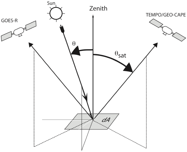
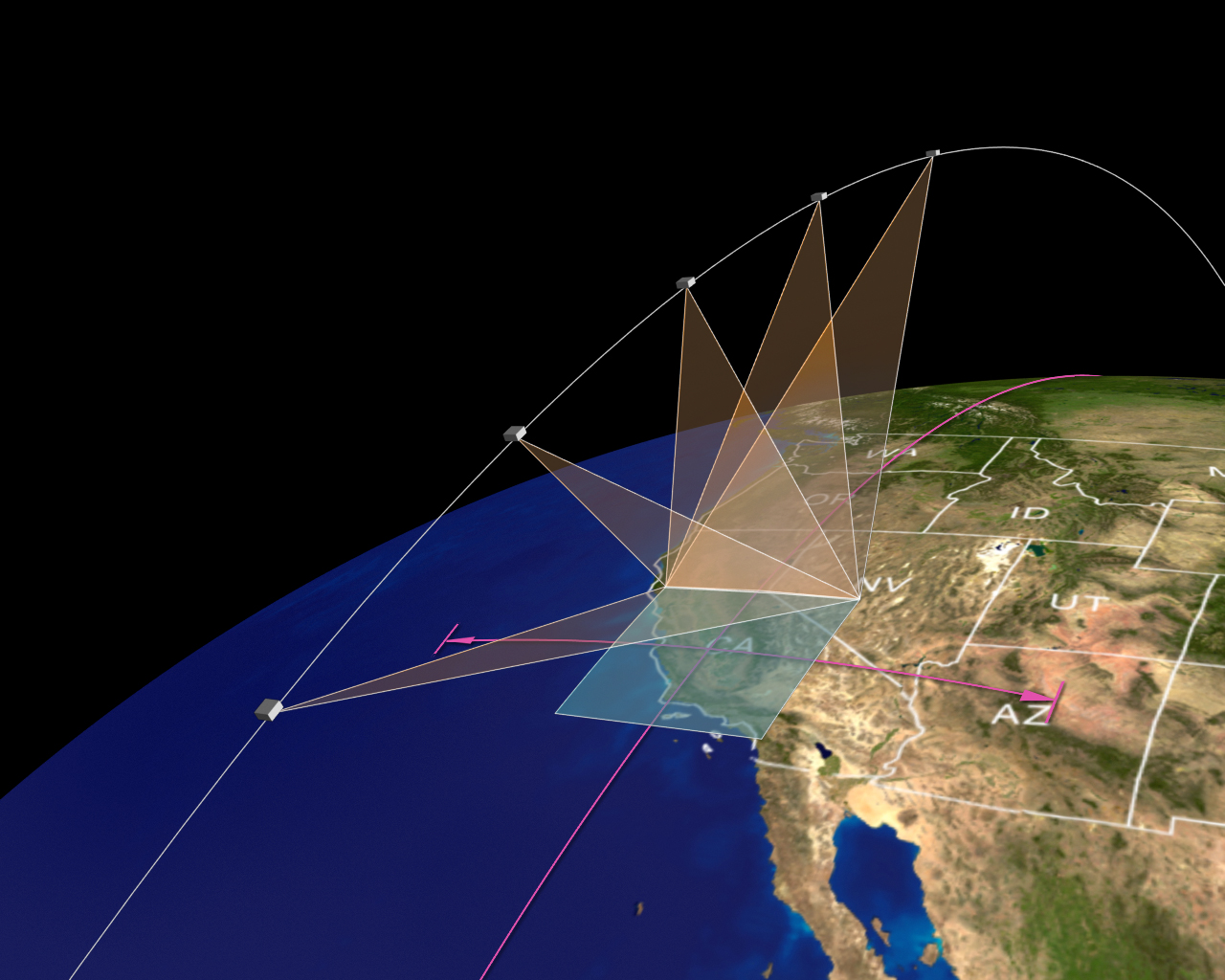
Satellite mission, TEMPO (Tropospheric Emission: Monitoring of Pollution), was selected by NASA in 2012 and is scheduled to be launched via SpaceX in 2022. TEMPO will provide hourly measurement of aerosol and trace gases over the North America at spatial resolution of 4-8 km2 as well as the possibility to measure the spectra of city lights at night (Zoogman et al., 2017). It will usher an new era for atmospheric chemist research with a wide range of applications to improve the environmental protection, prediction of air quality, and protection of human health (Chance et al., 2019).

TEMPO
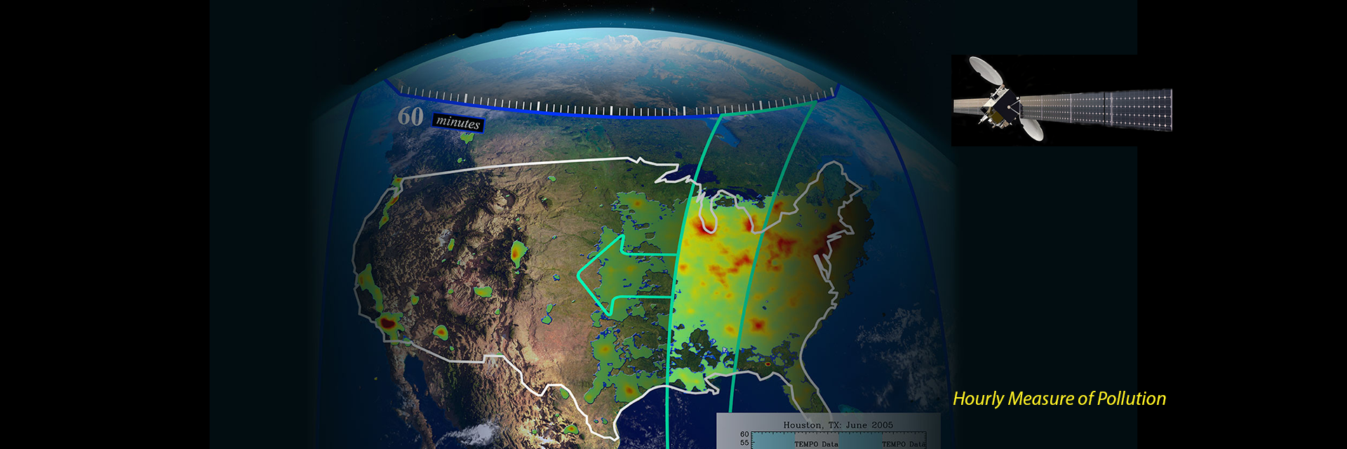
Graphic overview of TEMPO mission, source: http://tempo.si.edu/overview.html


Since the inception of TEMPO concept, AER Lab has been in close collaboration with the research team led by Dr. Kelly Chance, PI of TEMPO, in Smithsonian Astrophysical Observatory. As part of TEMPO investigation, AER team have developed novel algorithms and tools in preparation of using TMEPO data for the following:

  1. Hyperspectral retrieval of aerosol and surface properties from space at each hour, including PCA-based retrieval of aerosol and surface properties in hyperspectral resolution ( Hou et al., 2016, 2017, 2020)
  2. Retrieval of aerosol layer height using O2 B band (Chen et al., 2021)
  3. Numerical test for remote sensing of aerosols, clouds and gases (Wang et al., 2014; Xu and Wang, 2019)
  4. Synergy of multiple geostationary satellites for retrievals of aerosol properties. As early as in 2003, AER lab has showed the feasibly of using hourly observations (equivalent to multiple scattering angles) from a geostationary satellite to derive the phase function of non-spherical particles and the AOD thereafter (Wang et al., 2003). The TEMPO and its synergy with other geostationary satellites (such as GOES-16, GOES-17, etc) is studied in Wang et al. (2014). The synergistic or joint retrieval improves the retrieval of both AOD and fine-mode AOD accuracy with a reduction of uncertainties 30% to 10% and from 40% to 20%, respectively. The improvement of AOD is especially evident when TEMPO is located in the (reflected) sunlight direct beam, the direction for which the surface bi-directional reflectance (BRDF) is largest.
    TEMPO

Satellite mission, Multi-Angle Imager for Aerosols (MAIA) , was selected by NASA in 2016 and will be launched in ~2024. It represents the first time NASA has partnered with epidemiologists and health organizations on a satellite mission to study human health and improve lives ( Diner et al., 2018)

MAIA
MAIA, source: https://maia.jpl.nasa.gov

Since the inception of MAIA concept, AER Lab has been in close collaboration with the research team led by Dr. David Diner, PI of TEMPO, in Jet Population Lab. As part of MAIA’s investigation, AER team have:

  1. added new developments for the community model, WRF-Chem, to improve the prediction and analysis of aerosol compositions in MAIA’s primary target areas (PTAs). The new developments enable Unified Initial conditions for WRF-Chem, or UI-WRF-Chem with the following features. It can take meteorological and atmospheric composition data from NASA’s MERRA-2 or GEOS-FP as boundary conditions. This enables unified and self-consistent boundary conditions for both meteorology and atmospheric chemistry to drive WRF-Chem. It improved soil NOx emission scheme that can potentially lead to the better simulation of O3 and nitrate particles (Sha et al., 2021). An ensemble Kalman-Filter technique is also developed to correct model output bias with surface and satellite observation data (Zhang et al., 2020; 2022).
  2. developed remote sensing theory to study multiple angle polarization in O2 A and B bands for passive remote sensing of aerosol layer height (Ding et al., 2016; Chen et al., 2021).

"I was there watching the launch and took this picture!
Vandenberg Air Force Base in California"

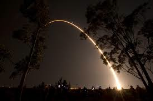
Suomi National Polar-orbiting Partnership (SNPP) satellite was launched in Oct. 2021. Designed as a mission to bridge the NOAA’s AVHRR series of satellite and the newer generation of Earth observation satellites, NPP is the result of a partnership between NASA, the National Oceanic and Atmospheric Administration, and the Department of Defense. AER Lab Director, Prof. Jun Wang, was the selected by NASA as the inaugural team member for SNPP science and was invited to watch its launch (see pictures below).

AER’s participation in SNPP mainly focuses on the application of VIIRS instrument to study fires and aerosols as well as the application of OMPS instrument to study atmospheric SO2 and NO2. Here are some highlights (and ongoing projects).

  1. Developed the first algorithm to combine visible and infrared measurements from VIIRS to improve the fire detection at night ( Polivka et al., 2017 ) to characterize the fire combustion efficiency ( Wang et al, 2020 ) for the first time, from space.
  2. Developed the first algorithm to use backscattered moonlight measured by the VIIRS to derive smoke aerosol optical depth at night in rural areas ( Zhou et al., 2021 ).
  3. Developed a method to characterize the artifacts in VIIRS infrared channels ( Polivka et al., 2016 ).
  4. Applied OMPS SO2 and NO2 data and VIIRS Day-and-Night band data to constrain the emissions of SO2 and NO2 in China via GEOS-Chem adjoint modeling ( Wang et al., 2020a , 2020b ).
  5. Developed an ensemble Kalman-Filter technique to correct model output bias with surface and satellite observation (including VIIRS) data (Zhang et al., 2020; 2022) ( Zhang et al., 2020; , 2022 ).